Wednesday, September 28, 2022

Exploring the sources of the 'Southern ancestry' in the Steppe


The proximal source of the southern (IranN/CHG) ancestry in the Eneolithic Steppe as well as Yamnaya populations has been a mystery. Chintalapati et al 2022 infer that the admixture between Eastern European Hunter-Gatherers and Iran Neolithic ancestry occurred between 4400-4000BCE, using the DATES algorithm developed by Moorjani Lab.

In this post, powered with newly published samples as well as better tools than before, I will attempt to decipher the true sources of these populations.

Disclaimer: The analysis presented below is based on the currently available published samples from the Pontic Caspian Steppe. The samples from the Middle Don region (Allentoft et al 2022 preprint) are unavailable, and this analysis will be updated once those samples become available.

Monday, September 19, 2022

The Lady from Central Asia who was found dead in a Bronze Age Turkish well


Site of the Alalakh 'Well Lady'. Courtesy: Skourtanioti et al 2020


The remains of the Alalakh 'Well Lady' were discovered in the archaeological site of Tell Atchana / Alalakh / Alalah, Turkey dating to ~1550BCE. Her aDna was published in 2020 (1) and she was found to be of central Asian origin, far from where she was found. She was found at the bottom of a deep well that was still in use at the time. The individual showed evidence of healed trauma on the skull's frontal bone and two healed fractured ribs, and her manner of death has been suggested as a homicide due to or before being thrown into the well (2). Her teeth also showed clear signs of enamel defects (2), a possible sign of malnutrition during childhood. Her age at death was 40-45 years.

Friday, September 9, 2022

Map of ancestry distribution in West to SC Asia during the Neolithic


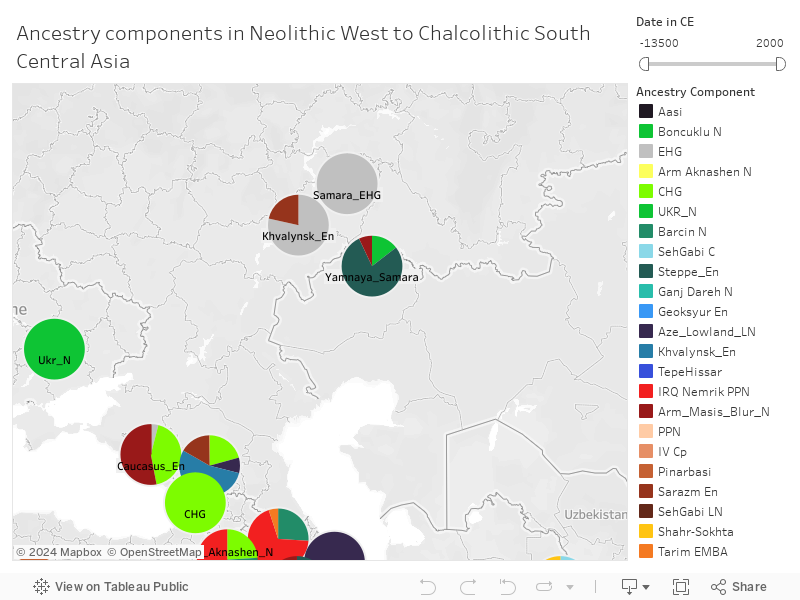
All the relevant populations from the early neolithic to chalcolithic are represented here. Most up to date map of population movements in the neolithic age, including the latest neolithic samples from Lazaridis et al 2022. All results have been arrived at using rigorous qpAdm rotating models.

If alternate model exists, I have noted them and will be visible once you hover on a label.

To pan the map, click the play button on the map and then and select the + button or Cross which enables the Pan cursor. Map can then be panned in all 4 directions. Pinch in/out to zoom. There is also a date filter.

Latitude/longitude of some labels might not be accurate. Co-ordinates of some labels have been shifted a bit so that there is less overlap between labels close to each other in location (eg. Seh_Gabi_LN, Seh_Gabi_C, Ganj_Dareh, Hajji_Firuz cluster; Arm_Masis_N, Arm_Aknashen, Aze_Lowlands cluster; Geoksyur & Gonur cluster; Boncuklu & Pinarbasi)